


Over at The Daily Beast we have an unusual story about the kind of adventure you can find yourself in during a pandemic lockdown and practically in your own backyard.
And it all started with a bicycle ride.
For space, we didn’t provide much background on why we were cycling up a local mountain that had recently been declared the highest peak in Rockland County after a new laser-based elevation analysis.
So we thought we’d explain our strange reasons for doing so here, at the Lowdown.
At some point in 2018 — the memory is vague — we became aware of the location of the highest point in the Bronx, and just for something to do we decided to cycle over to it from our home in southern Westchester County. It was not a difficult feat.
The Bronx’s high point is located in the exclusive Fieldston neighborhood, an early 20th century private development of detached homes just west of Van Cortlandt Park. Posted signs warn outsiders that they are entering a private community, and there was a distinct feeling that we were trespassing simply for pedaling slowly up a steep residential street.
The high point itself is located at an elevation of about 280 feet in the backyard of an intimidating mansion that was constructed in the last couple of years. Not wanting to trespass, we stood on the highest ground nearby, at the curb, and we were somehow thrilled at attaining our first county high point. Objectively, it was not an impressive exploit. It wasn’t like standing on Everest or the Matterhorn. And there wasn’t even anything to see except for the other huge houses nearby, each of them just a little lower than where we were standing. But for some reason the idea of being on that spot, with nothing else higher in the borough around us, and having arrived there under our own power on a bicycle, felt like an accomplishment.
A map nut, we were curious about other high points nearby and began learning their locations. And gradually, it dawned on us that it might be possible to ride to all five New York City borough peaks in a single day.
What made that discovery even more tantalizing was that in a few weeks the portentous number 55 was arriving.
Over several years we had developed a mostly pointless birthday ritual, a day’s ride at least as long in miles as our new age in years. But with 55 arriving, we had been looking for something more memorable than a 55-mile bike ride
So that’s how, on May 23, 2018, we ended up pedaling to the high points of the Bronx, Manhattan, Staten Island, Brooklyn, and Queens, for a total of 108 miles of cycling and 10 miles of sitting on the Staten Island Ferry. We left at 6 in the morning and didn’t get home until almost 9 at night. We suffered, and loved it.

In the process, had we invented a new sport? We had no idea. But cycling to high points had now become our new passion.
Two months later we set out on a six-day, 300-mile ride that would take us to four county high points, including the highest peak in the Catskills.
On the morning of July 10, 2018, we began the trip by riding north so we could catch a 9:06 am ferry leaving Ossining and crossing the Hudson River to the town of Haverstraw.
First on the agenda was the highest point in Rockland County, and what we couldn’t know at the time was the wrong peak.
—-
At more than 47,000 acres, Harriman State Park is the second largest in the state and takes up a sizable portion of New York’s smallest county outside New York City. It’s known for its hiking trails and wildlife, and it would be nice to say that riding to its semi-wilderness from the city was a pleasant experience.
It was a nightmare. The road up from Haverstraw is narrow and steep and heavily trafficked, the worst possible combination for a cyclist just minding his own business on the extreme right edge of the tarmac, grinding slowly against gravity and knowing he’s a sitting duck for drivers. All we could do was turn up the music in our earbuds and hope that no one flying by was driving drunk or had some kind of irrational hatred for a moist 55-year-old guy wearing black lycra pajamas and a styrofoam hat.
The heat of that July morning was playing tricks on our mind as we reached the steepest portion, an exposed section that felt like some kind of prank. Normally, cyclists benefit from the fact that paved roads tend to have been laid down on top of lanes created for horse-drawn carriages or during the early history of the automobile, which had a tendency to overheat on long climbs. You can usually plan on a road leveling out before too long to give a horse or a boiling radiator a break. But the pitch on this thing, and in this heat, felt like it must have been laid down by someone very cruel.
And then it was over. A friendly welcome sign marked the park boundary, and suddenly it was another world, a lush mountain forest surrounding radiant Lake Welch.
Another day we might have thought about stopping and wading in. But we were on a mission, and we went past the lake and began descending on the other side, looking for the hiking trail that was supposed to come down to the road. It wasn’t obvious, and we ended up overshooting it by almost a mile, requiring a painful uphill backtrack.
The terrain, the heat, the remoteness of the forest: It was all conspiring against us, but this was 2018 and we had a smartphone, a miracle of technology that we are too familiar with by now to appreciate properly. It told us our precise location thanks to satellites orbiting the earth and we were able to find the path, Beech Trail, which wasn’t really visible at all from the road.
We took the bike away from the road and locked it to a tree. We had already worked out what to bring in our bags, which cyclists call panniers, and in a few minutes we had unfolded a backpack, put our water bottles and helmet into it, threw on a baseball cap, and pulled out a small camera to record the hike.
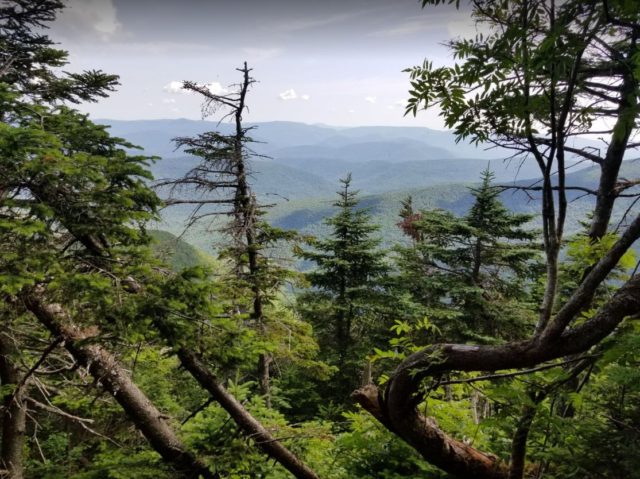
Getting to the top of Rockhouse Mountain required following Beech Trail for about a half mile and then leaving it to bushwack uphill to the left. After some panicky moments thrashing through grabby shrubs and thinking we had gotten lost we spotted what appeared to be the highest ground, a collection of small boulders surrounded by thick undergrowth. We scrambled onto the highest of the rocks.
There was no view except for the forest around us. After taking a few snapshots and then bushwacking back to the trail, we were soon back on the bike and racing downhill to what would be our stop for the night, a roadside motel in the town of Central Valley, well into Orange County. It was only there, after a shower and while having a plate of pasta at a local tavern where the France-Belgium World Cup semifinal was on the TV, that we realized Peakbagger.com had a “B” peak listed for Rockland County: Jackie Jones Mountain.
For some counties Peakbagger lists multiple high points that are all close in height in case later analysis proves that the official peak is not the highest. High pointers usually hike the alternate peaks too just to be careful. We cursed ourself for not paying closer attention. There was no way we could go back at this point. The next day we were moving on to Orange County’s high point, Schunemunk Mountain, and then on subsequent days to Sullivan County’s Beech Mountain and then Slide Mountain in Ulster County, at 4,180 feet the highest summit in the Catskills.
Anyway, we had Rockhouse Mountain in the bag. We tried to enjoy the match.
—-
By the time we noticed the 2019 update on Peakbagger about Doug Melton and his LiDAR data knocking down Rockhouse Mountain, we were well into planning for summer 2020 and looking for rides we could accomplish during a pandemic.
In some ways cycling during the coronavirus crisis had been amazing. Especially those first days, when there were almost no cars on the road and you could ride on empty major thoroughfares you wouldn’t dream of otherwise. But an overnight trip like our 2018 excursion would mean staying in hotels that we didn’t want to go near with the disease raging.
Multiple-day rides were out. And there were only a few counties left which were close enough to reach in a single day and that we hadn’t already stood on top of. Also, it felt somewhat demoralizing to think of going back to a county we had already ticked off in order to pick up a peak we should have climbed if we’d done better research the first time.
But one thing made the thought of going back to Rockland County and the steep climb to Harriman State Park less depressing.
And that was the Tappan Zee.
A wide spot in the Hudson River, it had been named after a local tribe, the Tappan, with the Dutch word for ‘sea,’ the first European settlers in the area. The first bridge across it was started in 1952 and opened in 1955.
The original Tappan Zee Bridge was built with WW2 technology and during Korean War shortages, and by the early 21st century it was obvious that it was aging badly. An ambitious new bridge was planned to replace it that would be designed to last at least a century without major upgrades.
One improvement in particular interested cyclists. The original Tappan Zee Bridge had no bike path and was closed to cyclists. The new bridge would have a lane just for pedestrians and bicycles. For years riders had anticipated the promised path on the new Tappan Zee Bridge, which had been formally named after former Governor Mario Cuomo and was opened to cars in August 2017. Bike activists grumbled that under the administration of Mario’s son, current Governor Andrew Cuomo, the new path was being overdesigned, leading to delays.
As the planned 2019 opening was pushed back into 2020, we kept checking for updates to see when it would open. The new path would be a more direct route to Rockland County, making its new high point, Jackie Jones Mountain, a destination we could more easily ride to and return from in a single day.
Complicating that plan, however, was that we would be taking our life in our hands just to get to the new bridge.
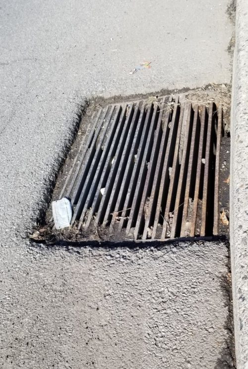
Activists had pointed out that roads leading to Mario Cuomo Bridge sported numerous hazards that the state’s Department of Transportation refused to do anything about. In particular, Tarrytown Road, which is heavily trafficked enough to carry the name Highway 119, contained the worst possible kind of drain grates, the kind that could literally prove fatal to a cyclist not paying close attention.
We’re not exaggerating. These are not the kind of grates that are merely troublesome because they might provide a jolt to riders. These are true wheel-suckers, with long narrow gaps that could swallow an entire front bicycle wheel. They’re like something out of the 1940s and during a period when bicycle riding by adults had all but disappeared in the US.
In the late 19th Century and early part of the 20th Century, bicycle riding and racing was as big as any sport in the country. But by the 40s and 50s and the major proliferation of the country’s superhighways, the bicycle had become a child’s toy. Midcentury road engineers had no motivation to consider cyclists, and it showed.
Besides the insanely dangerous grates (there were eleven of them over a one-mile stretch, we counted them), the road was simply one of the worst in the area for traffic and drivers hurrying to get to freeway entrances. We wanted to avoid Highway 119 at all cost.
So we had spent a few weeks that spring anticipating the new path opening by looking for an alternate way to get to the bridge. The most difficult thing about it from where we were coming from was that it was largely a ride to the west, and something you learn very quickly as a Westchester County cyclist is that east-west travel is a challenge.
That’s thanks to ancient glaciers.
Southern New York’s landscape was carved into north-south valleys because of glaciation during the last Ice Age, which is why there are so many ways to travel by car north and south (take your pick from the Henry Hudson, the Saw Mill, the Taconic, the Sprain Brook, the Bronx River, the Hutchinson, etc.) but traveling east-west is a hilly nightmare. It’s the glaciers.
After a dozen different experiments, we picked out a westerly and not too hilly or trafficked route to Dobbs Ferry and one of our favorite north-south connectors: The Old Croton Aqueduct trail. It’s a gravel path lying atop a buried aqueduct that was constructed between 1837 and 1842 to bring fresh drinking water to New York City. Remnants of it can be found along the entire 41-mile route from Old Croton Dam north of the city to its original terminus where Bryant Park is now in Manhattan, but the best-preserved section runs from Yonkers to Tarrytown, and would leave us just blocks from the new bridge.
We tested out the route several times, waiting for Governor Cuomo to open the new path, which he finally did on his father’s birthday, June 15.
We rode across it along with the large first-day crowd. The public art and overlook spots were nicely done, the traffic noise from the cars was surprisingly deafening, and the elevation and wind over the water made crossing its 3.6-mile length and coming back a significant effort. But the views of the Hudson more than made up for it.
Six days later, on June 21, the longest day of the year, we got up early, rode across town to the OCA path and up to the bridge (stopping briefly to fix a flat), crossed it on the new path to charming Nyack, and then traveled north on the secluded and scenic Hudson River Greenway Trail to Haverstraw.
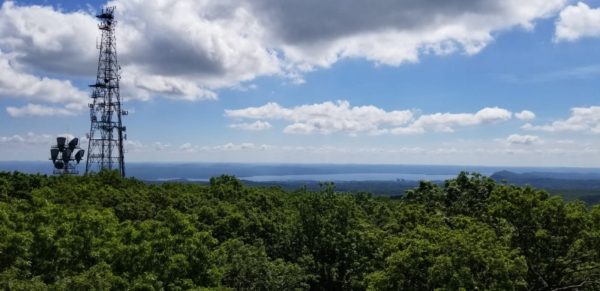
This time, we had picked out a different route up to the state park that spared us some of the worst parts of the climb we’d been up two years before. But still there was that knee-cracking final section to the park boundary. This time, instead of going on to Lake Welch, we turned left onto the road for the top of Jackie Jones Mountain itself. It was blocked to cars, and we were alone on the the steep shaded lane. It was a pleasure to cycle nearly all the way to the top of the mountain, where there was an old fire tower.
The view from the top of the tower was spectacular. Below us was Lake Welch, bathed in strong sunlight on the summer solstice. Its wide sandy beach was populated with hundreds of tiny figures, sunbathers who from that distance looked like pepper sprinkled on salt.
It was a do-over ride that was required only because we hadn’t paid attention two years earlier, but we were glad to do it. Of all the county high points we’ve done (20 so far, in New York, New Jersey, and Connecticut, all ridden to on a bicycle), it was by far the most stunning.
And as we left to ride down the mountain and go the long way home over Bear Mountain Bridge for an 80-mile complete loop, we couldn’t get one thought out of our mind.
Who the hell was Jackie Jones?
Two days later we sent an email to Marianne B. Leese, senior historian of the the Historical Society of Rockland County, asking what we hoped was an easy question to answer.
(For what happened next, please see ‘Who the Hell was Jackie Jones and Why is a Mountain Named for Him?’ at The Daily Beast.)
————-
THE LOWDOWN is our blog for news, features, and other subjects not related to our coverage of the Church of Scientology. If it’s our Scientology coverage you’re looking for, please use this bookmark for our latest stories.
Posted by Tony Ortega on May 29, 2021 at 08:00

